
Although long overdue, I have finally finished my blog about
my trip to Antarctica. It’s impossible to accurately describe the incredible things
that I experienced and the powerful lessons that I learned in the world’s
coldest, highest, driest, and windiest desert, so I have instead opted to provide
a day-by-day synopsis of my expedition with Professor David Marchant and
graduate student Andrew Christ.
In the future I will write more about particular
experiences, but for now, here is the 4th and final entry in a 4 part “Month in the Life of an
Antarctic Researcher” series.

1/2/2016
This was another long, arduous, but very fun day. Professor
Marchant, Drew, and I hiked down to the bottom of the valley, to the modern
glacier and moraine. There we sampled and collected several rock samples for
cosmogenic nuclide dating.
 |
On the right-hand side of the picture are the base of the valley and the modern
moraine where we hiked.
|
 |
| Looking down to the bottom of the valley. The bright blue color is glacial ice, located where we hiked. The descent is much steeper than it looks in this picture. |
 |
| Looking out onto the glacier from the modern moraine. |
We also collected ice samples. In the middle of the
moraine, we saw our second mummified seal of the trip. It was as interesting
and disturbing as the first.
 |
| Mummified seal from modern moraine. |
1/3/2016
After hiking to the bottom of the valley the previous day,
we hiked to the top of the valley on this day. It was another steep and
difficult hike, though not quite as difficult as the previous day’s. From the
top of a ridge we were able to see the edge of the ice sheet that extended inland
for hundreds of miles in one direction, and in the other direction we had a
fantastic view of the entire valley.
 |
| The edge of Antarctica's massive ice sheet. |
 |
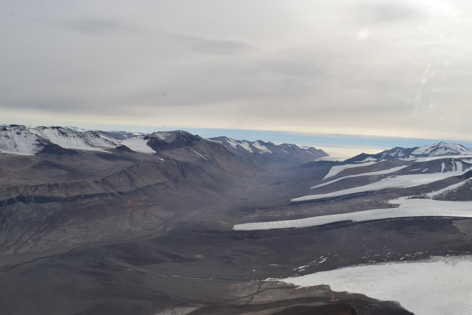
| A view of the valley. On the lower left-hand side are many of the moraines from which we sampled. |
From this vantage point, we took several
GigaPan shots—panoramic images composed of tens or hundreds of individual shots.
These GigaPans will later be used to perform virtual field observations in the comfort
and warmth of Boston University’s Digital Image Analysis Lab (DIAL).
 |
| The GigaPan mount. We took hundreds of shots from this vantage point. These images will later be stitched together to form a large panorama of the valley. |
The
panoramas generated are so high-quality that Professor Marchant and Drew will
be able zoom in from a panorama of the entire valley to observe individual
rocks and boulders (including those we sampled and collected!).
We also
finalized our plans for a camp move on 1/6/2016 to Mount Boreas in the Olympus
Range where we would collect rock samples for cosmogenic nuclide dating.
Professor Marchant and his colleagues have already determined how long this environment
has been stable and therefore how long ago rocks were deposited by glaciers.
Comparing these dates with the dates given by measuring the ratios of
cosmogenic nuclides would demonstrate how well the technique of cosmogenic
nuclide dating works, especially over long time scales.
1/4/2016
Our last day of sampling at our Mackay Glacier camp! Drew,
Professor Marchant, and I collected our last few rock and soil samples from
near our camp. It was a relatively relaxing day compared to our last 3 days of
intense hiking.
1/5/2016
Our second-to-last day at the Mackay Glacier site was,
unfortunately, a snow day. With heavy snowfall and low visibility, we were
forced to stay in our tents for the day. Our flight to Mount Boreas was also delayed
one day due to weather.
1/6/2016
We spent most of this day taking GigaPans of the region that
we hadn’t already shot on the 4th. We took as many pictures of the
area as possible since it was our last day and we might never have the opportunity
to revisit.
 |
| The view of Sperm Bluff from where we took our GigaPans. It is so named because it resembles the body of a whale. Do you see the tail? |
1/7/2016
We woke up early to pack up our camp in preparation for our
12:15 flight to Mount Boreas. It took a few hours to pack up our tents, food,
rock samples, and scientific equipment for the helicopters to either bring with
us to Mount Boreas or take back to McMurdo. Packing up camp was about as
difficult as setting it up because we had to remove all of the heavy rocks
weighing down our tent and then tie up the tents and all of our equipment. It
was nice to see the helicopter pilots and crew because at that point we
hadn’t seen any other humans in over 2 weeks!
The hour-long flight to Mount Boreas was one of the most
incredible hours of my life. We flew though the Dry Valleys and saw some of the
largest, most breathtaking natural wonders in the world. I took over 700
pictures, but none of them seemed to accurately capture the enormity of the mountains,
valleys, and lakes we saw.
 |
| A view from the helicopter ride to Boreas. |
 |
| This shot shows the depth of the valleys (but doesn't accurately capture the enormity of the place). |
 |
| A modern glacier and modern lake as seen from our helicopter to Mount Boreas. |
 |
| Our first view of Mount Boreas. The looming snow clouds worried us, but actually led to no snow at our camp site. |
 |
| The helicopter that brought us from Mackay Glacier to Mount Boreas. Photo Credit: Andrew Christ |
Once we landed at our camp location, in the shadow of Mount
Boreas, we began the process of, once again, setting up our tents and
equipment. Without the ubiquitous boulders of our Mackay Glacier camp, it was
much easier to walk around and find a suitably flat area to set up camp.
Professor Marchant, Dave, and I took a brief reconnaissance hike to determine
where we would collect our rock samples for the next few days.
 |
| Our new home, with Mount Boreas in the background. |
1/8/2015
This was undoubtedly the best day of my entire Antarctic
experience. In fact, it was one of the most incredible and memorable days of my
life. After collecting a few samples near our camp, Drew and I took a hike to
explore the area more while Professor Marchant continued surveying our campsite
for rock samples. After a fairly long but easy hike (compared to the difficult
hiking at the Mackay Glacier Camp) we came across some of the most amazing natural
wonders I have ever seen. We saw the Asgard Mountains, The Labyrinth, and Ice
Falls. The Asgards are some of Antarctica’s most impressive mountains. The
Labyrinth is a long region running through the Transantarctic Mountains that
gets its name because of the extensive network of channels that have been
eroded into the bedrock. Ice Falls (its full name is actually Airdevronsix Icefalls)
is a line of ice falls that meets the Labyrinth.
 |
| The Labyrinth. |
 |
| Me, with Airdevronsix Icefalls in the background. |
It was probably the most
incredible thing I saw on our trip. At several hundred meters high, it reminded
me of a frozen Niagara Falls. Drew and I took hundreds of pictures, but we can
never forget how amazing and awe-inspiring this experience was.
 |
| A closer view of Airdevronsix Icefalls. |
As we returned to camp, large storm clouds loomed overhead.
We could see snow over the nearby Apocalypse Peaks, which spelled bad news for
us. Thankfully, though, we had managed to collect a few important samples, and
would not need much more time to collect all of the samples we thought were
necessary.
1/9/2016
The storm clouds that we saw the previous day did indeed
bring us much undesired snow. Over an inch of snow fell overnight, leaving us
in our tents for the day. We decided that the next afternoon would be our best
chance to find the remaining samples we needed. We also finalized our departure
date—our last day in the field—for 1/11.
 |
| Our camp after the snowfall. Compare to the image above, and note that almost no rocks can be seen on the ground. This prohibits geological field work. Photo Credit: Andrew Christ. |
1/10/2016
As we had planned the day before, we collected rock samples
in the afternoon of what was to be our last day in the field (or so we
thought). Although it was one of our shortest working days, it was perhaps the
coldest day of the trip. With high winds and some blowing snow, the short work
day was very painful and seemed to last much longer than the few short hours we
were outside.
1/11/2016
Our flight back to McMurdo was delayed and then cancelled
early in the morning. Severe weather conditions at McMurdo along with
suboptimal flying conditions near our camp made it impossible for any
helicopters to safely bring us back. We rescheduled our flight out for 1/12 in
hopes that the bad weather would clear up and we could make it safely back to
McMurdo.
1/12/2016
We made it to McMurdo! After waking up very early, we packed
up all of our gear and flew back on a 9:30am helicopter flight. Our flight back
lasted about an hour, and was another amazing, scenic ride.
 |
| Looking out over Boreas as we took off (the blurry black line at the top of the picture is a whirring helicopter blade). |
We flew through more
of the Dry Valleys where we saw many more enormous mountains, deep valleys, and
many glaciers.
 |
| A modern lake, mostly frozen over, as seen from our helicopter. |
 |
| A helicopter with a view. |
 |
| A typical look at the ubiquitous brown and white mountains and valleys. |
 |
| A world of ice and rock. |
The glaciers were quite spectacular. Some looked like slowly oozing pancake batter while others seemed to defy gravity.
 |
| Glaciers slowly flowing into a valley. |
 |
| I thought this one looked like pancake batter. |
 |
| Gravity defying ice, flowing over a ledge. |
We also flew over
the Ross Ice Shelf where we saw vast expanses of ice extending all the way to
the ocean. It was a breathtaking exit from the field; it made our trip all the
more memorable.
 |
| A mosaic in the ice. |
This was also the first time in 2016, and actually the first
time in over three weeks, that I got to shower! It was the cleanest, the
warmest, and the most comfortable I had been in a long time. Although I was sad
to be leaving an environment like no other, it was also a relief to once again
have access to even the simplest luxuries of the modern world.
1/13/2016
We spent the entire day in McMurdo but we did a lot of work.
Most of the day was spent packaging all 110 of our rock samples for transport
back to the United States. This required a lot of heavy lifting—not as much as
our collection day at Mackay Glacier camp (see 1/1/2016 entry), but still very
difficult. We also began packing our other supplies for storage, for shipment
back to the United States, or for another day trip. Because Professor Marchant
and Drew thought that it would help to have more algae samples for Carbon
dating, we scheduled one final day trip to Black Island for the next day, 1/14.
 |
| Most of McMurdo (with some buildings cut off on either side). |
1/14/2016
Professor Marchant, Drew, and I woke early and dressed for
our flight to Black Island that left McMurdo around 9:45am. After the short
flight, we spent around 6 hours searching for buried algae. We found several
independent samples, making it a successful last day in the field!
 |
| Fun Meter set to Max! Our pilot's helmet was a good indication of how our last day at Black Island, and really our entire trip, would pan out. |
On the
flight back to Black Island—perhaps my last flight ever in a helicopter– I sat
in the front the helicopter, next to the pilot. It was a great chance to get
some last-minute photographs of McMurdo, Black Island, and other nearby
features. After our helicopter landed,
our field season was officially over.
 |
| Mt. Erebus over McMurdo. This was my view from the front seat of the helicopter. It is one of the last pictures I took in Antarctica. In the center of the picture, beneath the snow covered volcano, you can see the town McMurdo, where we would return from our last outing about a minute after this shot was taken. |
The feeling of returning forever was one
of both sadness and relief; I would never forget the incredible experiences
that I had on the expedition, but I was glad to be returning back to my family
and friends whom I hadn’t seen or been in contact with for over a month.
1/15/2016
 |
| Snow or sun, we were always smiling. |
Although it was our last day on the continent, this was one
of our busiest days. We had to finish packing all of our equipment and samples
for shipment back to the United States since we had been on our day trip to
Black Island the previous day and we would be leaving for New Zealand the
following day. We also had to return all of the medical supplies, scientific
instruments, and camping equipment that had been loaned to us by different
facilities and agencies in McMurdo.
We went to bed early since we would have to be up for a 8am flight off the continent the next morning. This marked my last night living on the most austere and inhospitable continent on earth. It was the end of the greatest journey I have ever taken, and likely ever will take.
As a 19-year-old, I got to go on a priceless, once-in-a-lifetime expedition to participate in some of the most interesting and important scientific research on earth. I was, and forever will be, incredibly grateful to Boston University, and the BURECS program. None of this would have been possible without their never-ending effort and dedication. But even more than that, I am thankful to have been able to do this with Professor Marchant and Drew, whose kindness, humor, intelligence, and selflessness made my month in Antarctica, however difficult, one of the most enjoyable and fraternal of my life.
 |
| Professor Marchant and me, ready for a day of work. Photo Credit: Andrew Christ. |
 |
| Drew and me on a sunny day at Mackay Glacier. Photo Credit: David Marchant. |
No comments:
Post a Comment